 FAO Map Catalog
Contact for the resource
Water Resources and Irrigation in Africa (AQUASTAT)
Type of resources
Available actions
Topics
Keywords
Contact for the resource
Provided by
Years
Representation types
Update frequencies
status
Scale
From
1
-
1
/
1
-
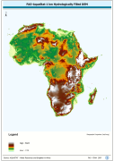
WRIA_DEM: Hydrologically filled GTopo30 DEM with the main stems of cartographic rivers "burned-in" for irrigation analysis. GT30/GTopo30 is Global Topographic 30 arc second DEM database, nominal 1km postings; DEM is Digital Elevation Model. The WRIALAEA grid data layer is comprised of 9194x8736 derivative raster hydrologically filled dem features derived based on 1 kilometer data originally from FAO.